|
|
|
|
|
|
|
|
|
|
|
|
|
|
|
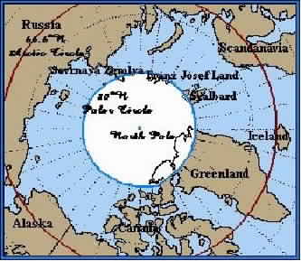
| Map showing the Arctic Circle (red) at 66.5�N and the Polar Circle (blue) at 80�N. While the Arctic Circle is a fixed point on the earth's surface--the point at and above which, due to the curvature of the earth, there is at least one day per year of total light, the Polar Circle is a more or less arbitrary point used to designate the area around the north geographic pole at 90N. |
|
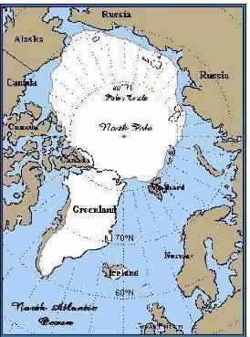
| The North Geographic Pole or True North, as opposed to Magnetic North or the magnetic north pole to which magnetic compasses point, lies at the center of the vast Arctic Ocean or polar sea. Since the polar ice pack is constantly in motion moved by wind and currents, there is no means to permanently mark the location of the north geographic pole. |
|
| As can be seen from the map, a great deal of land area lies to the north of the Arctic Circle, including parts of northern Alaska, the high Canadian Arctic, most of Greenland (Denmark), northernmost Iceland, parts of Scandinavia and the Russian Arctic. However, the only land areas lying within the Polar Circle are northermost Ellesmere Island (Canada), northern Greenland, northernmost Svalbard (Norway), Franz Josef Land (Russia), and Severnaya Zemelya (Russia). |
|
| Unlike the north polar region that consists of water, the Arctic Ocean, surrounded by land, the south polar region at the opposite end of the earth consists of land, the Antarctic continent, surrounded by water, the Southern Ocean. |
|
|
|
|
|
|
|
|
|
|
|
|
|
|
|
|
|
|
| Some Common Conversions |
| |
| Much of the polar literature employs the metric system to express values. Below are some rule-of-thumb conversions to more familiar U.S. values: |
| |
| Distances |
| One meter = 39 inches (3 ft., 3 in. or 3� ft.) |
| To convert meters to feet, multiply meters by 3.25 |
| Ex.: 500 meters = 500 X 3.25 = 1625 feet. |
| |
| One degree of latitude ( � ) = 60 nautical miles. (There are 60 minutes [ ' ] of latitude in one degree; one minute of latitude = one nautical mile). |
| One nautical mile (nm.) = 1.15 statute miles (sm.). |
| To convert nautical miles to statute miles, multiply nautical miles by 1.15. |
| Ex.: 60 nm. = 60 X 1.15 = 69 sm. |
| |
| One kilometer (km.) = 0.62 statute miles |
| To convert kilometers to statute miles, multiply kilometers by .62 |
| Ex.: 100 km. = 100 X .62 = 62 sm. |
| |
| |
| Temperatures |
| To convert centigrade (Celsius) to Fahrenheit, multiply centigrade by 1.8 and add 32. |
| Ex.: 15�C = 15 X 1.8 = 27 + 32 = 59�F |
| 0�C = 0 X 1.8 = 0 + 32 = 32�F |
| [0� and 32�F are the freezing points of water; water boils |
| at 100�C and 212�F]. |
| |
| |
| Note that at very low temperatures such as might be encountered in the polar regions, centigrade and Fahrenheit values are much closer together. |
| �30�C = �22�F |
| �40�C is the same as �40�F |
| �50�C = �58�C |
|
|